About Nomads Roam
At Nomads Roam, we are passionate adventure enthusiasts with a deep love for the outdoors. With our expertise in outdoor gear, we offer a curated selection of high-quality products for outdoor enthusiasts like yourself. Our commitment to customer satisfaction drives us to provide top-notch camping equipment, outdoor gear, tents and shelters, and much more. Join us on your next outdoor escapade and gear up for unforgettable adventures.
Nomads Haus Family
Nomads Haus is a collective that provides Property Design and Development, Interior Design services, Van and Mobile Home Renovation and Rentals, and lastly, through Nomad Roam, Outdoor Gear. The team consists of architects, interior designers, graphic designers, and landscapers focused on creating beautiful spaces and services tailored to the nomad experience.
Category: Category: Outdoor Safety
Jun 5, 2023
Essential Navigation Skills: Reading Maps and Using a Compass
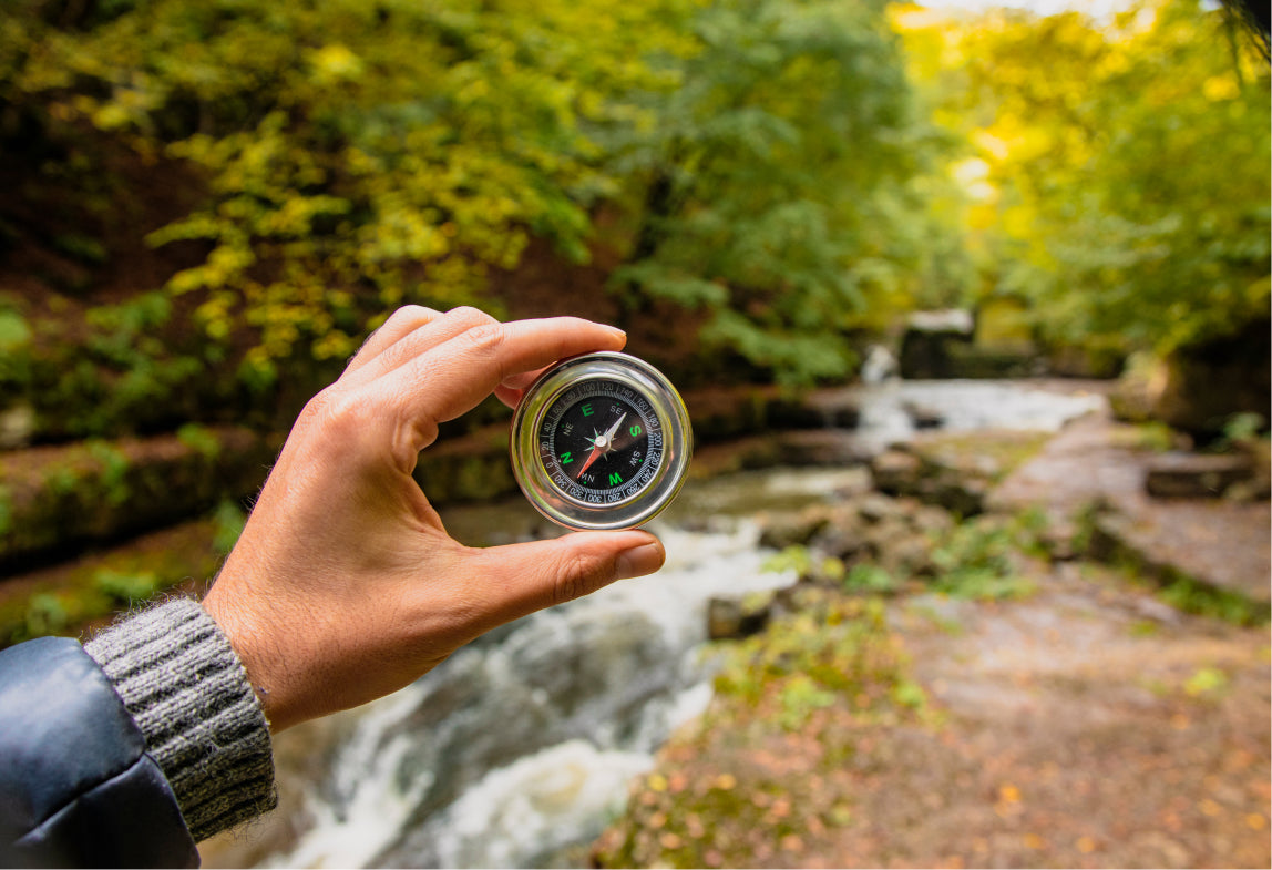
In an era where technology often guides our every step, it's easy to underestimate the importance of acquiring timeless navigation skills such as reading maps and using a compass. However, when the digital world falters and the possibility of being stranded without GPS or a phone becomes a reality, these traditional skills emerge as invaluable allies. Picture yourself in the midst of the great outdoors, surrounded by nature’s beauty, but finding yourself disconnected from the digital grid. Sure, not all those who wander are lost, but in moments like these, you will be beyond grateful to know how to interpret a map and navigate with a compass. So, join us as we dive into the art of map reading and compass navigation, exploring their timeless relevance and understanding the reassurance they provide when we must rely solely on our own abilities to find our way.
1. Get to know your compass
- Magnetized Needle
- Housing or Case
- Direction-of-Travel Arrow
- Compass Rose
- Baseplate
- Rotating Bezel
- Index Line
- Orienting Lines or Markings
- Declination Adjustment


*In this post, we’ll go over everything you need to know about the anatomy of a basic compass.
Magnetized Needle: A magnetized needle in a compass is a lightweight needle that aligns with the Earth's magnetic field, indicating the direction of magnetic north. Typically, they are colored red or white.
Housing or Case: The housing or case of a compass is the protective enclosure that contains the internal components of the compass, such as the magnetized needle and markings. It also provides a clear viewing window for reading compass directions and ensures the stability of the compass during use. The housing often includes cardinal direction markings and other useful information.
Direction-of-Travel Arrow: The Direction-of-Travel Arrow in a compass is an arrow or indicator that points in the direction that the traveler is moving in. It helps hikers align with their intended direction and assists in maintaining a consistent heading, ensuring accurate navigation.
Compass Rose: The Compass Rose is a circular marking on the compass that displays the cardinal directions (north, south, east, west). It helps users orient themselves and determine their heading accurately.
Baseplate: The Baseplate is a flat, transparent surface with ruler markings on the compass. It provides stability and allows for measuring distances on maps, aiding in navigation and route planning. It is clear enough to allow you to see the map beneath it and will help you take bearings to transfer to your map.
Rotating Bezel: The Rotating Bezel is a marked ring around the compass housing and has 360-degree markings. It is used to set and measure bearings or angles, enabling users to navigate with greater precision.
Index Line: The Index Line is a marking or indicator on the compass housing. It helps users align the compass with their desired direction of travel, aiding in accurate navigation and maintaining a consistent heading.
Orienting Lines or Markings: Orienting Lines or Markings on the compass, typically on the baseplate or housing, help users align the compass with maps. They allow for matching the compass's orientation with the map's orientation, facilitating accurate navigation.
Declination Adjustment: Declination Adjustment is a feature found in most compasses. It allows users to correct for the difference between true north and magnetic north based on their location. It ensures more precise navigation in areas with significant magnetic declination.
Now that you know the parts of your compass, let's move on to navigating it.
2. Adjusting Declination
Adjusting declination on a compass involves correcting the variance between true north and magnetic north based on your location. This adjustment ensures more accurate navigation.
To adjust declination on a compass:
- Find the declination value for your location from maps or online resources.
- Determine if the declination is East or West.
- Locate the declination adjustment feature on your compass (e.g., a screw or dial).
- Use a tool to turn the adjustment feature in the appropriate direction.
- Rotate the adjustment until it aligns with the declination value for your location.
- The compass now indicates both magnetic north and true north, enhancing navigation accuracy.
Adjusting declination compensates for the variation between true north and magnetic north, allowing you to navigate more precisely. By aligning the compass with true north, you can account for the local magnetic deviation and navigate using accurate bearings and directions on maps.
However, you must first determine the declination value in your trip region before making an adjustment for it. The value is shown on topo maps, but it does change over time. Check the map's revision date or, for the best results, refer to the magnetic declination provided by the National Oceanic and Atmospheric Administration (NOAA).
3. Orienting your map
To orient a map means to align it with the surrounding physical features or the actual direction on the ground. This allows you to accurately interpret the map and navigate using it. Here’s a step by step guide on how to orient your map!
- Find a recognizable feature: Look for a distinct physical feature on the map, such as a mountain peak, a river, or a well-known landmark that you can easily spot in the surrounding environment.
- Position the map: Hold the map in front of you, ensuring that it is facing the same direction as the surrounding area. Hold it at a comfortable distance and angle that allows you to see both the map and the surrounding landscape.
- Align the map with the feature: Rotate the map until the identified feature on the map is in line with the corresponding feature in the actual environment. Be sure to align the edges of the map, so it matches the orientation of the surrounding area.
- Use a compass: Place your compass flat on the map with the direction-of-travel arrow pointing towards the top of the map. Rotate the map until the compass needle aligns with the orienting lines on the compass. This further ensures that the map is correctly aligned with the true north.
- Turn the bezel so that N (north) is parallel to the arrow indicating the direction of travel.
- Move the baseplate until either the left or right edge of your map is in line with one of its straight edges. (The arrow indicating the direction of travel should still be pointing up the map.)
- Then, while maintaining your grip on the map and compass, turn your body until the magnetic needle's tip is contained by the arrow's outline.
- Verify alignment: Check other prominent features on the map and compare them to the surrounding landscape. Ensure that the alignment of the map with the actual environment is consistent and accurate.
Now that the map is properly oriented, you can use it to locate and identify nearby landmarks. Before you set out, take some time to get acquainted with your map and the area. As you travel, keep reading your map. You may reliably read and interpret the map in respect to the topography in the area by properly positioning it. This makes it possible to navigate efficiently, plan routes accurately, and understand your location and direction on a map more clearly.

4. Taking a Bearing
When reading a map, a bearing refers to the direction from one point to another, expressed as an angle relative to a reference point, usually true north or magnetic north. It helps you determine the direction to follow when navigating between locations on a map.
Bearings are typically measured in degrees, with 0 degrees representing north, 90 degrees representing east, 180 degrees representing south, and 270 degrees representing west. Intermediate directions can be expressed as well, such as northeast (45 degrees), southeast (135 degrees), southwest (225 degrees), and northwest (315 degrees).
To read a bearing on a map, you identify the starting point and the destination, and then measure the angle between the reference direction (true north or magnetic north) and the line connecting the two points. This bearing can be used to guide your navigation by aligning it with the compass or by visually referencing landmarks or features on the ground.
By understanding bearings and using them in conjunction with a compass or landmarks, you can accurately navigate and follow specific directions on a map to reach your desired destination.
*Remember: Bearings are always based on a relative location. The same bearing taken from two different locations will not lead you to the same place.
- Begin by identifying the starting and destination points. Locate your current position on the map (e.g., a landmark or your current campsite) and the destination you want to navigate towards.
- Lay the compass on the map with the edge of the baseplate connecting your starting point and destination. Ensure that the direction-of-travel arrow on the compass points toward the destination.
- While keeping the compass still, rotate the compass housing until the compass needle aligns with the orienting lines within the compass housing. The north end of the needle should be pointing to magnetic north or true north, depending on the type of compass.
- Now read the bearing. Look at the degree marking or index line on the compass housing where it intersects the direction-of-travel arrow. This reading represents the bearing from your starting point to the destination.
- Follow the bearing. To navigate, hold the compass level and point the direction-of-travel arrow in the direction of the bearing you took. Make sure you rotate your body until the magnetized needle is inside the orienting arrow. Keep the compass aligned as you walk, ensuring the arrow remains pointing in the same direction.
You can even use a bearing to find where you are on a map!

To do this,
- Find a landmark that is visible on your map.
- The direction of travel arrow on your compass should be pointing directly at the landmark and away from you when you hold it flat.
- Once the magnetized needle is situated inside the orienting arrow, turn the bezel once more.
- To interpret the bearing you just captured, look at the index line.
Then, you need to transfer that bearing to your map.
- Place your compass on the map and position a straight edge so that one corner corresponds to a landmark.
- Rotate the entire base plate until the orienting lines are running north/south (6b) and the north marker on the bezel is pointing to north on the map (6c), making sure that the direction of travel arrow continues to point in the general direction of the landmark (6a).
- Using the compass's straight edge, you can now draw a line on the map in position 7a. Your location is shown by the line from the landmark crossing your trail (7b).
And that's it!
Developing and honing the essential navigation skills of reading maps and using a compass is crucial for anyone venturing into the great outdoors. These skills empower adventurers to find their way with precision and self-reliance. So, take the time to learn and practice these skills, and let your journey be guided by the timeless art of reading maps and using a compass. As always, we hope to see you again. Happy trails!
Explore Nomads Roam's wide range of camping gear and elevate your outdoor experience. Shop now and embark on your next adventure fully equipped.
